Geology At Wilcox Hollow. December 2, 2012
Posted by littlebangtheory in Art and Nature.Tags: basalt, deerfield river, geology field trips, granitic gneiss, Shelburne Falls, Shelburne MA, UMass geology, Western Mass Geology, Wilcox Hollow
trackback
Those of you who come here with any regularity know that I live along the Deerfield river in Western Massachusetts, and that many of my photographs are of that river and its environs as it wends its way from Southern Vermont past my home to its terminus at the Connecticut river south of Greenfield, MA.
Along the way it passes named points – The Dryway and Zoar Gap, where whitewater paddlers play; Shelburne Falls, where the famous “Potholes” have attracted Indian fishermen, artists and, more recently, tourists; Stillwater, where campers and fishermen steep themselves in the languid waters of the Lower Deerfield, deep and slow and tranquil.
Here’s a glimpse of a spot just below Shelburne Falls: Wilcox Hollow, a low meadow on “river left,” the Shelburne side (across the river is the town of Buckland,) which is being conserved and allowed to return to something like a natural state.
I ran into a group of UMass geology students there this past week. They were looking at the riverside geology, taking notes and photos and sharing observations:

The consensus (and I concurred) was that this place was a lithic mess, with its “history” obscured by so many events over the last 400 million years that the true history was unclear.
I mean, WTF is this???
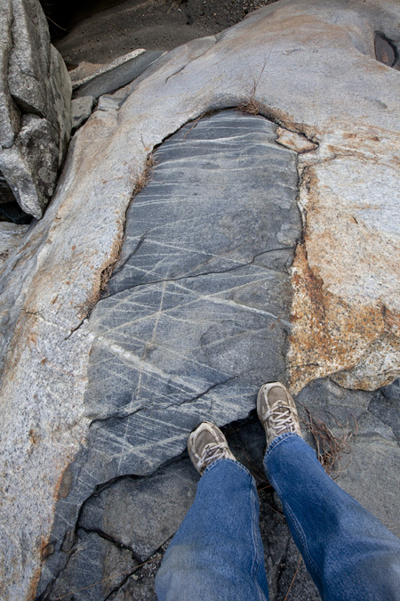
OK, so the light brown rock is granitic gneiss, folded into undulating waves. The darker stuff is an interbedded sill of something broadly basaltic, perhaps a diorite, metamorphosed to where there are hornblends clearly visible without a hand lens. And through it all are the light banded “scratches,” which extend down through the interbedded layers, showing that they’re in fact later-forming fractures which have filled with… what? Perhaps quartz, which is difficult to melt at high heat, but water soluble under high pressure.
It’s all so confusing!
These young folks were fortunate to be learning at the hands of Professor Mike Williams, chair of the UMass Department of Geosciences. I understand that he’s currently engaged in pioneering techniques of mineral dating which are yielding amazingly precise results. At any rate, he was fully present for his riverside class, and still had time to answer a few of my pedestrian questions about what I was looking at in the record at my feet. Thanks, Professor Williams.
But in the end, I’m no geologist. I’m a photographer with an interest in geology.
So here are some artsy-fartsy black and white photos I took when I wasn’t standing slack-jawed with amazement.
Roots revealed by Storm Irene’s violent denuding of so much of the Deerfield’s banks:

The feathered edge of a thin layer of something “broadly basaltic:”

…with a cross-hatching of fractures filled with a lighter-colored mineral;
And a pothole carved into the granitic gneiss by a swirling rock, something harder, perhaps a piece of basalt:

This place isn’t beautiful on a landscape scale, but it holds a treasure trove of details for those with the time and patience to explore its nooks and crannies.
I’ll doubtless be back soon for more surprises.

I’ve been puzzling over what to get my father for Xmas and I think a good quality print of the 3/4 photo (broadly basaltic) might just be it. Dad’s a civil engineer by trade and a fellow photographer by avocation. Email me so we can figure out details?
Robyn, thanks for asking. Contact me, ralph@ralphmunn.com for sizes/prices.
Thank you for posting this! I love your part of the world!
My pleasure, Marjorie.